Projections of Future Change
Scientists use a variety of techniques to make projections of the possible state of planet Earth and in the future, and in particular its climate. They tend to use the word “projection” rather than “prediction” since the latter suggests a single expected outcome, rather than a variety of outcomes that each have a different likelihood.
The most appropriate technique depends very much on the particular event, or climate variable in question, and the level of accuracy required in the answer.
The ice2sea programme is engaged in making projections of the contribution of glaciers and ice sheets to sea-level rise, over the next 100 – 200 years. For this, task several different approaches will need to be employed.
The contribution of glaciers in mountainous regions around the world is best addressed using statistical models of glaciers’ response to climate change. Working in partnership with other programmes, ice2sea will develop a new digital gazetteer describing the world’s glaciers on which to base projections. This gazetteer will contain information about the areas, elevation, and location of more than 150,000 glaciers worldwide. It will provide the basis for running a statistical model of glacier change driven by the output of a global climate model. This will provide a projection of global climate for the future. The statistical model will be developed and tuned against the measured responses of real glaciers over recent decades.
A rather different approach is required to make projections of the contribution of ice sheets to sea-level rise. There are only two ice sheets left on the planet (in Antarctica and Greenland) and our understanding of how these ice sheets have changed in the past is precise only for the last two decades, for which we have satellite data. This means that there is insufficient data on which to develop statistical models. For this task we will use a suite of more sophisticated computer programmes (models) that attempt to simulate the processes occurring within the ice sheets, and how they will change under the outside influences of a changing climate. This is a similar approach to that used to produce projections of global climate, but has several specific features:
- Because there is no single ice-sheet model which is accepted as being the most accurate, ice2sea needs to use several models driven by the same climate forcing to establish the degree of certainty that can be put on our projections.
- An ice sheet can take decades to millennia to fully response to a change in climate, so our models must capture current changes (which were caused by past climate changes) as well as those that will be caused by future climate change. [To do this we use a class of models that are somewhere between models that predict future climate change on the timescale of decades to centuries (that take little account of the precise conditions on the day projections start), and weather-prediction models (which make predictions over just a few days that are completely reliant on a good description of global weather patterns on day-one of the projection).]
- Since ice sheets respond both to changes in the atmospheric conditions (specifically, temperature, and snowfall rates) and to changes in the oceans around them (specifically, the melting caused by warm ocean water coming into contact with the ice), our projections of ice-sheet change will be derived using both projections of atmospheric and oceanographic change.

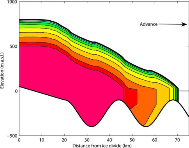
The results of a model of glacier retreat in response to an increase in iceberg calving. The time interval between the profiles is 50 years. Reference ice2sea publication #007. Credit Faezeh Nick, GEUS, Denmark
Expected outcomes
The ice2sea Stakeholder Review has shown that coastal defence planners and the policy-makers to whom they report may be interested in specific aspects of sea-level projections depending on the nature of their coastlines and the economic assets for which they are responsible. Those that have to maintain protection for major cities, or nationally-owned infrastructure, often require scientists to make projections of maximum plausible sea-level rise, since their planning needs to take account of even unlikely events. Where the protection of coastal assets is the responsibility of local authorities, or even individuals, the emphasis may be on establishing a plan to deal to the most likely sea-level rises. For this reason ice2sea will aim to communicate both the most likely and the “maximum plausible” sea-level rise projections, and give a range of certainty attached to each.
Finally, ice2sea will make an assessment of where uncertainty arises in the projection process. Does it arise in our uncertainty about future emission of greenhouse gases (the fundamental cause of much of the expected future climate change)? Or in how these emissions will alter global, regional, or oceanic climate? Or finally, how the ice sheets and glaciers of the world respond to these changes. An improved understanding of the chain of how uncertainty arises in the process will allow better targeting of future resources in reducing that uncertainty.


